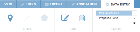
Data Entry gives users the ability to create and edit data. The ability to edit data is controlled by your IntraMaps system administrator. Features drawn into a Data Entry Layer will be added to the selected layers and seen by all users.

This tool will allow you to place a symbol on the Map Window. The small arrow to the right of the button allows different symbols to be chosen. Click on the desired symbol, and then click in the map to draw the symbol in the map. The colour and size of the symbol can be set using the tools "Colour" and "Width" tools described at the end of this article.

This tool will allow you to draw a line on the Map Window. Click on the small drop down arrow to the right of this button and select the line style you wish to use. To start drawing your object left-click in the Map Window. This will anchor the start point of your line. As you drag the mouse away from this point you will see a line back to this point. Left click again at each 'corner' of the line you are creating. To finalise and apply the line you are drawing double left-click. Alternatively, you can press the "Esc" key to cancel the draw.


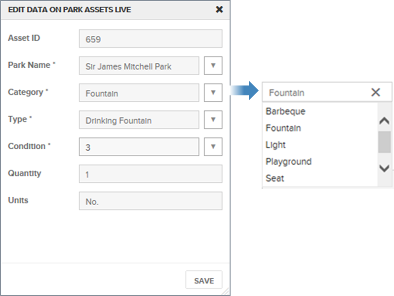
The Edit tool is used to alter data in the specified data entry layer. To use, select the object to edit and the tool will become active. Left click on the tool to display the attribute input dialog.
The Edit tool is only enabled when a data entry form has been configured on one of the selection layers located under the Selection Layer drop down box. As a result it is only possible to have one data entry template for each selection layer within a module.

This tool will allow you to remove any symbols, lines, or polygons. To delete, select the object to delete and the tool will become active. Left click on the tool, the object will be deleted and the map will refresh to reflect this.
Data Entry provides the ability for users to create edit and delete data. The ability to edit data is controlled by your IntraMaps system administrator. Layers that are available for editing can be selected using the Selection Layer drop down box. Once the layer you wish to edit is specified use the Symbol, Line, and Polygon tools as described above to create an object. Some of these tools may be unavailable. This depends on how the data entry template was configured by the system administrator and the data feature type.
Once you have drawn the desired object onto the map window a dialog will appear allowing attribute information to be entered for the new object. Required fields are indicated with a *. Click the Save button to finalise and apply your data entry or the cancel button to abort the data entry.
When using the Edit tool this dialogue will also appear.
|
SQL Server data sources can only be used as data sources when using data entry. Symbolisation or newly created objects is determined by the configuration of the layer in the Map file. Consequently, any styles chosen by the user may be over-ruled by the styles defined by the Administrator. |